Log in
All resources
Create a design
212 Free Images of 1720 Maps
maps in the rijksmuseum amsterdam
copperplate print
special collections of the university of amsterdam
maps from university of amsterdam special collections
atlas der neederlanden
prints published by pieter schenk (ii)
prints of cartouches in the rijksmuseum amsterdam
joachim ottens
bibliothèque nationale de france
guillaume sanson
historical
history
prints in the british museum
jacob folkema
1720s fashion
realism
maps of ghent by petrus schenck
historical
history
danubius pannonico-mysicus
1720s maps of hungary
eran laor cartographic collection
johann christoph haffner
maps from university of amsterdam special collections
atlas der neederlanden
maps from university of amsterdam special collections
atlas der neederlanden
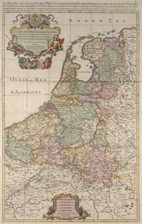
sanson maps of the netherlands
cartouches by sanson family
danubius pannonico-mysicus
1720s maps of hungary
maps from university of amsterdam special collections
atlas der neederlanden
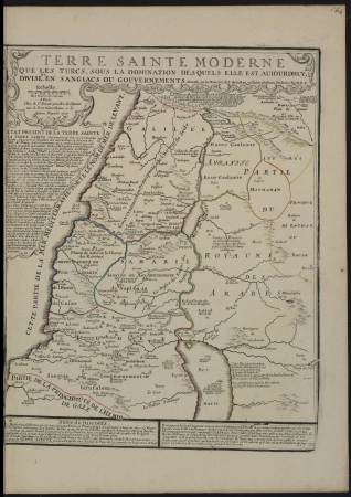
old maps of ancient israel
1720s maps of palestine
maps from university of amsterdam special collections
atlas der neederlanden
maps from university of amsterdam special collections
atlas der neederlanden
maps from university of amsterdam special collections
atlas der neederlanden
danubius pannonico-mysicus
1720s maps of hungary
maps from university of amsterdam special collections
atlas der neederlanden
maps from university of amsterdam special collections
atlas der neederlanden
maps from university of amsterdam special collections
atlas der neederlanden
1720s maps of slovenia
1725 maps
maps from university of amsterdam special collections
atlas der neederlanden
maps from university of amsterdam special collections
atlas der neederlanden
the hague in the 1720s
old maps of the hague
het groote tafereel der dwaasheid (1720)
maps in the rijksmuseum amsterdam
prints by jan luyken in the rijksmuseum amsterdam
maps in the rijksmuseum amsterdam
carte des pays-bas catholiques by guillaume sanson
cartouches by sanson family
1720s maps of palestine
nicolas de fer
eran laor cartographic collection
joachim ottens
het groote tafereel der dwaasheid (1720)
maps in the rijksmuseum amsterdam
maps from university of amsterdam special collections
atlas der neederlanden
het groote tafereel der dwaasheid (1720)
maps in the rijksmuseum amsterdam
het groote tafereel der dwaasheid (1720)
maps in the rijksmuseum amsterdam
het groote tafereel der dwaasheid, 1720
maps in the rijksmuseum amsterdam
het groote tafereel der dwaasheid (1720)
maps in the rijksmuseum amsterdam
maps from university of amsterdam special collections
atlas der neederlanden
het groote tafereel der dwaasheid, 1720
maps in the rijksmuseum amsterdam
historical
history
old maps of ghent
jacques chereau
het groote tafereel der dwaasheid (1720)
maps in the rijksmuseum amsterdam
het groote tafereel der dwaasheid, 1720
maps in the rijksmuseum amsterdam
maps from university of amsterdam special collections
atlas der neederlanden
considérations géographiques et physiques sur les nouvelles découvertes au nord de la grande mer
1755 maps of north america
maps from university of amsterdam special collections
atlas der neederlanden
historical
history
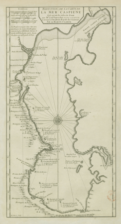
map of the caspian sea by guillaume delisle (1720s)
maps by gerard valck
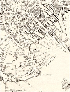
internet archive document dayswaysinoldbos00ross 0
days and ways in old boston (1915)
the hague in the 1720s
old maps of the hague
prints by caspar luyken in the rijksmuseum amsterdam
maps in the rijksmuseum amsterdam
1727 maps of africa
1720s maps of egypt
1727 maps of africa
1720s maps of egypt
maps from university of amsterdam special collections
atlas der neederlanden
maps from university of amsterdam special collections
atlas der neederlanden
danubius pannonico-mysicus
luigi ferdinando marsigli
maps from university of amsterdam special collections
atlas der neederlanden
het groote tafereel der dwaasheid (1720)
maps in the rijksmuseum amsterdam
bibliothèque nationale de france
carolus allard
claude desgots
jean mariette
18th-century maps of the caspian sea
claude auguste berey
prints by caspar luyken in the rijksmuseum amsterdam
maps in the rijksmuseum amsterdam
palais royal (1634–1763)
gilles-marie oppenord
historical
history
prints by caspar luyken in the rijksmuseum amsterdam
maps in the rijksmuseum amsterdam
internet archive document dayswaysinoldbos00ross 0
days and ways in old boston (1915)
british library king's topographical collection
william henry toms
prints published by pieter schenk (ii)
maps in the rijksmuseum amsterdam
prints published by pieter schenk (ii)
maps in the rijksmuseum amsterdam
prints of cartouches in the rijksmuseum amsterdam
maps in the rijksmuseum amsterdam
prints of cartouches in the rijksmuseum amsterdam
maps in the rijksmuseum amsterdam
map collection of leibniz-institut für länderkunde
1720s maps of the iberian peninsula
maps in the rijksmuseum amsterdam
etchings of ostriches
prints of coats of arms in the rijksmuseum amsterdam
maps in the rijksmuseum amsterdam
prints published by pieter schenk (ii)
maps in the rijksmuseum amsterdam
maps by nicolas sanson
1720s maps of france
maps in the rijksmuseum amsterdam
hendrik de leth
prints of cartouches in the rijksmuseum amsterdam
maps in the rijksmuseum amsterdam
old maps of the strait of gibraltar
maps in the rijksmuseum amsterdam
prints of cartouches in the rijksmuseum amsterdam
maps in the rijksmuseum amsterdam
maps in the rijksmuseum amsterdam
old maps of 's-hertogenbosch
maps in the rijksmuseum amsterdam
gilliam van der gouwen
maps in the rijksmuseum amsterdam
gilliam van der gouwen
etchings in the rijksmuseum amsterdam
works after adolf van der laan
prints published by pieter schenk (ii)
maps in the rijksmuseum amsterdam
prints by adolf van der laan in the rijksmuseum amsterdam
prints published by pieter schenk (i)
carte des côtes de malabar et de coromandel (1723)
philippe buache
prints of cartouches in the rijksmuseum amsterdam
maps in the rijksmuseum amsterdam
prints by romeyn de hooghe in the rijksmuseum amsterdam
maps in the rijksmuseum amsterdam
prints published by claes jansz. visscher (ii) in the rijksmuseum amsterdam
maps in the rijksmuseum amsterdam
maps in the rijksmuseum amsterdam
old maps of suriname
prints of cartouches in the rijksmuseum amsterdam
maps in the rijksmuseum amsterdam
maps in the rijksmuseum amsterdam
maps by isaak tirion
prints of cartouches in the rijksmuseum amsterdam
maps in the rijksmuseum amsterdam
prints published by claes jansz. visscher (ii) in the rijksmuseum amsterdam
maps in the rijksmuseum amsterdam
album met het prentwerk schouwtoneel van den oorlog
maps in the rijksmuseum amsterdam
prints of cartouches in the rijksmuseum amsterdam
maps in the rijksmuseum amsterdam
maps in the rijksmuseum amsterdam
17th-century celestial maps
maps in the rijksmuseum amsterdam
caspar specht
maps in the rijksmuseum amsterdam
abraham allard
prints published by pieter schenk (ii)
maps in the rijksmuseum amsterdam
prints of cartouches in the rijksmuseum amsterdam
maps in the rijksmuseum amsterdam
101 - 200 of 212
Next page
/ 3


![Special map of a part of Dutch Brabant, Guelders and Cleves or the surroundings of Grave, Ravestein, Helmont, Nijmegen, Fort de Schenk, Cleves, Gennip, Emmerick &c. / I. Condet f. 1748, Johannes Condet, [1748]](https://cdn.creazilla.com/illustrations/10000963180/special-map-of-a-part-of-dutch-brabant-guelders-and-cleves-or-the-surroundings-of-grave-ravestein-helmont-nijmegen-fort-de-schenk-cleves-gennip-emmerick-c-i-condet-f-1748-johannes-condet-1748-md.jpg)


![Holland, Zeeland, Brabant Map - Bergen op Zoom, Johannes Condet, [1748]](https://cdn.creazilla.com/illustrations/10001181342/holland-zeeland-brabant-map-bergen-op-zoom-johannes-condet-1748-md.jpg)


![Private carte d'une partie de la Hollande, et du Brabant Hollandois, ou les environs de Breda, Boisleducq, Geertruydenberg, Heusden, Dordrecht, Bommel &c. / I. Condet f. 1748, Johannes Condet, [1748]](https://cdn.creazilla.com/illustrations/10000996562/private-carte-dune-partie-de-la-hollande-et-du-brabant-hollandois-ou-les-environs-de-breda-boisleducq-geertruydenberg-heusden-dordrecht-bommel-c-i-condet-f-1748-johannes-condet-1748-md.jpg)

![Particular map of the Moluccas Islands / J.V.S. direx, Jakob van der Schley, [1763]](https://cdn.creazilla.com/illustrations/10001387577/particular-map-of-the-moluccas-islands-jvs-direx-jakob-van-der-schley-1763-sm.webp)


![Carte particuliere d’Amstelland, ou Les environs d’Amsteldam, Muyden, Weesp, Naarden &c. = Particuliere kaart van Amstellandt, of Het omleggende van Amsteldam, Muyden, Weesp, Naarden &c. / I. Condet f[ecit] 1749, Johannes Condet](https://cdn.creazilla.com/illustrations/10000681404/carte-particuliere-damstelland-ou-les-environs-damsteldam-muyden-weesp-naarden-c-particuliere-kaart-van-amstellandt-of-het-omleggende-van-amsteldam-muyden-weesp-naarden-c-i-condet-fecit-1749-johannes-condet-md.jpg)
![Carte des Isles Philippines, Celebes et Moluccas = Map of the Philippines, Celebes, and Moluccas Islands / J. v. Schley direct, Jakob van der Schley, [1747]](https://cdn.creazilla.com/illustrations/10001211531/carte-des-isles-philippines-celebes-et-moluccas-map-of-the-philippines-celebes-and-moluccas-islands-j-v-schley-direct-jakob-van-der-schley-1747-md.jpg)

![Carte particuliére de l'Isle d'Amboine / J. V. Schley direct, Jakob van der Schley, [1763]](https://cdn.creazilla.com/illustrations/10000789471/carte-particuli-re-de-l-isle-d-amboine-j-v-schley-direct-jakob-van-der-schley-1763-sm.jpg)